Release 9.2
Part No. A96630-01
 Library |
 Product |
 Contents |
 Master Index |
 Index |
 Feedback |
| Oracle® Spatial User's Guide and Reference Release 9.2 Part No. A96630-01 |
|


The MDSYS.SDO_LRS package contains functions that create, modify, query, and convert linear referencing elements. These functions do not change the state of the database.
|
Note: Most Oracle LRS interfaces are functions. Any that are procedures, such as DEFINE_GEOM_SEGMENT, are identified as such. (Functions return a value; procedures do not return a value.)The word functions is often used to refer to LRS interfaces (both functions and procedures) collectively. |
To use the functions in this chapter, you must understand the linear referencing system (LRS) concepts and techniques described in Chapter 6.
Table 14-1 lists functions related to creating and editing geometric segments.
Table 14-1 Functions for Creating and Editing Geometric Segments
| Function | Description |
|---|---|
| SDO_LRS.DEFINE_GEOM_SEGMENT (procedure) | Defines a geometric segment. |
| SDO_LRS.REDEFINE_GEOM_SEGMENT (procedure) | Populates the measures of all shape points of a geometric segment based on the start and end measures, overriding any previously assigned measures between the start point and end point. |
| SDO_LRS.CLIP_GEOM_SEGMENT | Clips a geometric segment (synonym of SDO_LRS.DYNAMIC_SEGMENT). |
| SDO_LRS.DYNAMIC_SEGMENT | Clips a geometric segment (synonym of SDO_LRS.CLIP_GEOM_SEGMENT). |
| SDO_LRS.CONCATENATE_GEOM_SEGMENTS | Concatenates two geometric segments into one segment. |
| SDO_LRS.OFFSET_GEOM_SEGMENT | Returns the geometric segment at a specified offset from a geometric segment. |
| SDO_LRS.SCALE_GEOM_SEGMENT | Scales a geometric segment. |
| SDO_LRS.SPLIT_GEOM_SEGMENT (procedure) | Splits a geometric segment into two segments. |
| SDO_LRS.REVERSE_MEASURE | Returns a new geometric segment by reversing the original geometric segment. |
| SDO_LRS.TRANSLATE_MEASURE | Returns a new geometric segment by translating the original geometric segment (that is, shifting the start and end measures by a specified value). |
| SDO_LRS.REVERSE_GEOMETRY | Returns a new geometric segment by reversing the measure values and the direction of the original geometric segment. |
Table 14-2 lists functions related to querying geometric segments.
Table 14-2 Functions for Querying Geometric Segments
| Function | Description |
|---|---|
| SDO_LRS.VALID_GEOM_SEGMENT | Checks if a geometric segment is valid. |
| SDO_LRS.VALID_LRS_PT | Checks if an LRS point is valid. |
| SDO_LRS.VALID_MEASURE | Checks if a measure falls within the measure range of a geometric segment. |
| SDO_LRS.CONNECTED_GEOM_SEGMENTS | Checks if two geometric segments are connected. |
| SDO_LRS.GEOM_SEGMENT_LENGTH | Returns the length of a geometric segment. |
| SDO_LRS.GEOM_SEGMENT_START_PT | Returns the start point of a geometric segment. |
| SDO_LRS.GEOM_SEGMENT_END_PT | Returns the end point of a geometric segment. |
| SDO_LRS.GEOM_SEGMENT_START_MEASURE | Returns the start measure of a geometric segment. |
| SDO_LRS.GEOM_SEGMENT_END_MEASURE | Returns the end measure of a geometric segment. |
| SDO_LRS.GET_MEASURE | Returns the measure of an LRS point. |
| SDO_LRS.MEASURE_RANGE | Returns the measure range of a geometric segment, that is, the difference between the start measure and end measure. |
| SDO_LRS.MEASURE_TO_PERCENTAGE | Returns the percentage (0 to 100) that a specified measure is of the measure range of a geometric segment. |
| SDO_LRS.PERCENTAGE_TO_MEASURE | Returns the measure value of a specified percentage (0 to 100) of the measure range of a geometric segment. |
| SDO_LRS.LOCATE_PT | Finds the location of a point described by a measure and an offset on a geometric segment. |
| SDO_LRS.PROJECT_PT | Returns the projection point of a point on a geometric segment. |
| SDO_LRS.FIND_LRS_DIM_POS | Returns the position of the measure dimension within the SDO_DIM_ARRAY structure for a specified SDO_GEOMETRY column. |
| SDO_LRS.FIND_MEASURE | Returns the measure of the closest point on a segment to a specified projection point. |
Table 14-3 lists functions related to converting geometric segments.
Table 14-3 Functions for Converting Geometric Segments
| Function | Description |
|---|---|
| SDO_LRS.CONVERT_TO_LRS_DIM_ARRAY | Converts a standard dimensional array to a Linear Referencing System dimensional array by creating a measure dimension. |
| SDO_LRS.CONVERT_TO_LRS_GEOM | Converts a standard SDO_GEOMETRY line string to a Linear Referencing System geometric segment by adding measure information. |
| SDO_LRS.CONVERT_TO_LRS_LAYER | Converts all geometry objects in a column of type SDO_GEOMETRY from standard line string geometries without measure information to Linear Referencing System geometric segments with measure information, and updates the metadata. |
| SDO_LRS.CONVERT_TO_STD_DIM_ARRAY | Converts a Linear Referencing System dimensional array to a standard dimensional array by removing the measure dimension. |
| SDO_LRS.CONVERT_TO_STD_GEOM | Converts a Linear Referencing System geometric segment to a standard SDO_GEOMETRY line string by removing measure information. |
| SDO_LRS.CONVERT_TO_STD_LAYER | Converts all geometry objects in a column of type SDO_GEOMETRY from Linear Referencing System geometric segments with measure information to standard line string geometries without measure information, and updates the metadata. |
For more information about conversion functions, see Section 6.5.10.
The rest of this chapter provides reference information on the functions, listed in alphabetical order.
Format
SDO_LRS.CLIP_GEOM_SEGMENT(
geom_segment IN MDSYS.SDO_GEOMETRY,
start_measure IN NUMBER,
end_measure IN NUMBER
) RETURN MDSYS.SDO_GEOMETRY;
or
SDO_LRS.CLIP_GEOM_SEGMENT(
geom_segment IN MDSYS.SDO_GEOMETRY,
dim_array IN MDSYS.SDO_DIM_ARRAY,
start_measure IN NUMBER,
end_measure IN NUMBER
) RETURN MDSYS.SDO_GEOMETRY;
Description
Returns the geometry object resulting from a clip operation on a geometric segment.
|
Note: SDO_LRS.CLIP_GEOM_SEGMENT and SDO_LRS.DYNAMIC_SEGMENT are synonyms: both functions have the same parameters, behavior, and return value. |
Parameters
Cartographic representation of a linear feature.
Dimensional information array corresponding to geom_segment, usually selected from one of the xxx_SDO_GEOM_METADATA views.
Start measure of the geometric segment.
End measure of the geometric segment.
Usage Notes
An exception is raised if geom_segment, start_measure, or end_measure is invalid.
start_measure and end_measure can be any points on the geometric segment. They do not have to be in any specific order. For example, start_measure and end_measure can be 5 and 10, respectively, or 10 and 5, respectively.
The direction and measures of the resulting geometric segment are preserved (that is, they reflect the original segment).
The _3D format of this function (SDO_LRS.CLIP_GEOM_SEGMENT_3D) is available. For information about _3D formats of LRS functions, see Section 6.4.
For more information about clipping geometric segments, see Section 6.5.3.
Examples
The following example clips the geometric segment representing Route 1, returning the segment from measures 5 through 10. This segment might represent a construction zone. (This example uses the definitions from the example in Section 6.6.)
SELECT  SDO_LRS.CLIP_GEOM_SEGMENT(route_geometry, 5, 10)
  FROM lrs_routes WHERE route_id = 1;

SDO_LRS.CLIP_GEOM_SEGMENT(ROUTE_GEOMETRY,5,10)(SDO_GTYPE, SDO_SRID, SDO_POINT(X,
--------------------------------------------------------------------------------
SDO_GEOMETRY(3302, NULL, NULL, SDO_ELEM_INFO_ARRAY(1, 2, 1), SDO_ORDINATE_ARRAY(
5, 4, 5, 8, 4, 8, 10, 4, 10))
Format
SDO_LRS.CONCATENATE_GEOM_SEGMENTS(
geom_segment_1 IN MDSYS.SDO_GEOMETRY,
geom_segment_2 IN MDSYS.SDO_GEOMETRY,
tolerance IN NUMBER
) RETURN MDSYS.SDO_GEOMETRY;
or
SDO_LRS.CONCATENATE_GEOM_SEGMENTS(
geom_segment_1 IN MDSYS.SDO_GEOMETRY,
dim_array_1 IN MDSYS.SDO_DIM_ARRAY,
geom_segment_2 IN MDSYS.SDO_GEOMETRY,
dim_array_2 IN MDSYS.SDO_DIM_ARRAY
) RETURN MDSYS.SDO_GEOMETRY;
Description
Returns the geometry object resulting from the concatenation of two geometric segments.
Parameters
First geometric segment to be concatenated.
Dimensional information array corresponding to geom_segment_1, usually selected from one of the xxx_SDO_GEOM_METADATA views.
Second geometric segment to be concatenated.
Dimensional information array corresponding to geom_segment_2, usually selected from one of the xxx_SDO_GEOM_METADATA views.
Tolerance value (see Section 1.5.5).
Usage Notes
An exception is raised if geom_segment_1 or geom_segment_2 has an invalid geometry type or dimensionality, or if geom_segment_1 and geom_segment_2 are based on different coordinate systems.
The direction of the first geometric segment is preserved, and all measures of the second segment are shifted so that its start measure is the same as the end measure of the first segment.
The _3D format of this function (SDO_LRS.CONCATENATE_GEOM_SEGMENTS_3D) is available. For information about _3D formats of LRS functions, see Section 6.4.
For more information about concatenating geometric segments, see Section 6.5.5
Examples
The following example defines the geometric segment, splits it into two segments, then concatenates those segments. (This example uses the definitions from the example in Section 6.6. The definitions of result_geom_1, result_geom_2, and result_geom_3 are displayed in Example 6-3.)
DECLARE
geom_segment MDSYS.SDO_GEOMETRY;
line_string MDSYS.SDO_GEOMETRY;
dim_array MDSYS.SDO_DIM_ARRAY;
result_geom_1 MDSYS.SDO_GEOMETRY;
result_geom_2 MDSYS.SDO_GEOMETRY;
result_geom_3 MDSYS.SDO_GEOMETRY;

BEGIN

SELECT a.route_geometry into geom_segment FROM lrs_routes a
  WHERE a.route_name = 'Route1';
SELECT m.diminfo into dim_array from
  user_sdo_geom_metadata m
  WHERE m.table_name = 'LRS_ROUTES' AND m.column_name = 'ROUTE_GEOMETRY';

-- Define the LRS segment for Route1.
SDO_LRS.DEFINE_GEOM_SEGMENT (geom_segment,
  dim_array,
  0,    -- Zero starting measure: LRS segment starts at start of route.
  27);  -- End of LRS segment is at measure 27.

SELECT a.route_geometry INTO line_string FROM lrs_routes a
  WHERE a.route_name = 'Route1';

-- Split Route1 into two segments.
SDO_LRS.SPLIT_GEOM_SEGMENT(line_string,dim_array,5,result_geom_1,result_geom_2);

-- Concatenate the segments that were just split.
result_geom_3 := SDO_LRS.CONCATENATE_GEOM_SEGMENTS(result_geom_1, dim_array, result_geom_2, dim_array);

-- Insert geometries into table, to display later.
INSERT INTO lrs_routes VALUES(
  11,
  'result_geom_1',
  result_geom_1
);
INSERT INTO lrs_routes VALUES(
  12,
  'result_geom_2',
  result_geom_2
);
INSERT INTO lrs_routes VALUES(
  13,
  'result_geom_3',
  result_geom_3
);

END;
/
Format
SDO_LRS.CONNECTED_GEOM_SEGMENTS(
geom_segment_1 IN MDSYS.SDO_GEOMETRY,
geom_segment_2 IN MDSYS.SDO_GEOMETRY,
tolerance IN NUMBER
) RETURN VARCHAR2;
or
SDO_LRS.CONNECTED_GEOM_SEGMENTS(
geom_segment_1 IN MDSYS.SDO_GEOMETRY,
dim_array_1 IN MDSYS.SDO_DIM_ARRAY,
geom_segment_2 IN MDSYS.SDO_GEOMETRY,
dim_array_2 IN MDSYS.SDO_DIM_ARRAY
) RETURN VARCHAR2;
Description
Checks if two geometric segments are spatially connected.
Parameters
First of two geometric segments to be checked.
Dimensional information array corresponding to geom_segment_1, usually selected from one of the xxx_SDO_GEOM_METADATA views.
Second of two geometric segments to be checked.
Dimensional information array corresponding to geom_segment_2, usually selected from one of the xxx_SDO_GEOM_METADATA views.
Tolerance value (see Section 1.5.5).
Usage Notes
This function returns TRUE if the geometric segments are spatially connected and FALSE if the geometric segments are not spatially connected.
An exception is raised if geom_segment_1 or geom_segment_2 has an invalid geometry type or dimensionality, or if geom_segment_1 and geom_segment_2 are based on different coordinate systems.
The _3D format of this function (SDO_LRS.CONNECTED_GEOM_SEGMENTS_3D) is available. For information about _3D formats of LRS functions, see Section 6.4.
Examples
The following example checks if two geometric segments (results of a previous split operation) are spatially connected.
-- Are result_geom_1 and result_geom2 connected?
SELECT  SDO_LRS.CONNECTED_GEOM_SEGMENTS(a.route_geometry,
           b.route_geometry, 0.005)
  FROM lrs_routes a, lrs_routes b
  WHERE a.route_id = 11 AND b.route_id = 12;

SDO_LRS.CONNECTED_GEOM_SEGMENTS(A.ROUTE_GEOMETRY,B.ROUTE_GEOMETRY,0.005)
--------------------------------------------------------------------------------
TRUE
Format
SDO_LRS.CONVERT_TO_LRS_DIM_ARRAY(
dim_array IN MDSYS.SDO_DIM_ARRAY
[, lower_bound IN NUMBER,
upper_bound IN NUMBER,
tolerance IN NUMBER]
) RETURN MDSYS.SDO_DIM_ARRAY;
or
SDO_LRS.CONVERT_TO_LRS_DIM_ARRAY(
dim_array IN MDSYS.SDO_DIM_ARRAY,
dim_name IN VARCHAR2
[, lower_bound IN NUMBER,
upper_bound IN NUMBER,
tolerance IN NUMBER]
) RETURN MDSYS.SDO_DIM_ARRAY;
or
SDO_LRS.CONVERT_TO_LRS_DIM_ARRAY(
dim_array IN MDSYS.SDO_DIM_ARRAY,
dim_name IN VARCHAR2,
dim_pos IN INTEGER
[, lower_bound IN NUMBER,
upper_bound IN NUMBER,
tolerance IN NUMBER]
) RETURN MDSYS.SDO_DIM_ARRAY;
Description
Converts a standard dimensional array to a Linear Referencing System dimensional array by creating a measure dimension.
Parameters
Dimensional information array corresponding to the layer (column of geometries) to be converted, usually selected from one of the xxx_SDO_GEOM_METADATA views.
Name of the measure dimension (M, if not otherwise specified).
Position of the measure dimension (the last SDO_DIM_ELEMENT object position in the SDO_DIM_ARRAY, if not otherwise specified).
Lower bound (SDO_LB value in the SDO_DIM_ELEMENT definition) of the ordinate in the measure dimension.
Upper bound (SDO_UB value in the SDO_DIM_ELEMENT definition) of the ordinate in the measure dimension.
Tolerance value (see Section 1.5.5).
Usage Notes
This function converts a standard dimensional array to a Linear Referencing System dimensional array by creating a measure dimension. Specifically, it adds an SDO_DIM_ELEMENT object at the end of the current SDO_DIM_ELEMENT objects in the SDO_DIM_ARRAY for the diminfo (unless another dim_pos is specified), and sets the SDO_DIMNAME value in this added SDO_DIM_ELEMENT to M (unless another dim_name is specified). It sets the other values in the added SDO_DIM_ELEMENT according to the values if the upper_bound, lower_bound, and tolerance parameter values.
If dim_array already contains dimensional information, the dim_array is returned.
The _3D format of this function (SDO_LRS.CONVERT_TO_LRS_DIM_ARRAY_3D) is available. For information about _3D formats of LRS functions, see Section 6.4.
For more information about conversion functions, see Section 6.5.10.
Examples
The following example converts the dimensional array for the LRS_ROUTES table to Linear Referencing System format. (This example uses the definitions from the example in Section 6.6.)
SELECT SDO_LRS.CONVERT_TO_LRS_DIM_ARRAY(m.diminfo)
   FROM user_sdo_geom_metadata m
   WHERE m.table_name = 'LRS_ROUTES' AND m.column_name = 'ROUTE_GEOMETRY';

SDO_LRS.CONVERT_TO_LRS_DIM_ARRAY(M.DIMINFO)(SDO_DIMNAME, SDO_LB, SDO_UB, SDO_TOL
--------------------------------------------------------------------------------
SDO_DIM_ARRAY(SDO_DIM_ELEMENT('X', 0, 20, .005), SDO_DIM_ELEMENT('Y', 0, 20, .00
5), SDO_DIM_ELEMENT('M', 0, 20, .005))
Format
SDO_LRS.CONVERT_TO_LRS_GEOM(
standard_geom IN MDSYS.SDO_GEOMETRY
[, start_measure IN NUMBER,
end_measure IN NUMBER]
) RETURN MDSYS.SDO_GEOMETRY;
or
SDO_LRS.CONVERT_TO_LRS_GEOM(
standard_geom IN MDSYS.SDO_GEOMETRY,
dim_array IN MDSYS.SDO_DIM_ARRAY
[, start_measure IN NUMBER,
end_measure IN NUMBER]
) RETURN MDSYS.SDO_GEOMETRY;
or
SDO_LRS.CONVERT_TO_LRS_GEOM(
standard_geom IN MDSYS.SDO_GEOMETRY,
m_pos IN INTEGER
[, start_measure IN NUMBER,
end_measure IN NUMBER]
) RETURN MDSYS.SDO_GEOMETRY;
Description
Converts a standard SDO_GEOMETRY line string to a Linear Referencing System geometric segment by adding measure information.
Parameters
Line string geometry that does not contain measure information.
Dimensional information array corresponding to standard_geom, usually selected from one of the xxx_SDO_GEOM_METADATA views.
Position of the measure dimension. If specified, must be 3 or 4. By default, the measure dimension is the last dimension in the SDO_DIM_ARRAY.
Distance measured from the start point of a geometric segment to the start point of the linear feature. The default is 0.
Distance measured from the end point of a geometric segment to the start point of the linear feature. The default is the cartographic length (for example, 75 if the cartographic length is 75 miles and the unit of measure is miles).
Usage Notes
This function returns a Linear Referencing System geometric segment with measure information, with measure information provided for all shape points.
An exception is raised if standard_geom has an invalid geometry type or dimensionality, if m_pos is less than 3 or greater than 4, or if start_measure or end_measure is out of range.
The _3D format of this function (SDO_LRS.CONVERT_TO_LRS_GEOM_3D) is available; however, the m_pos parameter is not available for SDO_LRS.CONVERT_TO_LRS_GEOM_3D. For information about _3D formats of LRS functions, see Section 6.4.
For more information about conversion functions, see Section 6.5.10.
Examples
The following example converts the geometric segment representing Route 1 to Linear Referencing System format. (This example uses the definitions from the example in Section 6.6.)
SELECT SDO_LRS.CONVERT_TO_LRS_GEOM(a.route_geometry, m.diminfo)
  FROM lrs_routes a, user_sdo_geom_metadata m
  WHERE m.table_name = 'LRS_ROUTES' AND m.column_name = 'ROUTE_GEOMETRY'
    AND a.route_id = 1;

SDO_LRS.CONVERT_TO_LRS_GEOM(A.ROUTE_GEOMETRY,M.DIMINFO)(SDO_GTYPE, SDO_SRID, SDO
--------------------------------------------------------------------------------
SDO_GEOMETRY(3002, NULL, NULL, SDO_ELEM_INFO_ARRAY(1, 2, 1), SDO_ORDINATE_ARRAY(
2, 2, 0, 2, 4, 2, 8, 4, 8, 12, 4, 12, 12, 10, NULL, 8, 10, 22, 5, 14, 27))
Format
SDO_LRS.CONVERT_TO_LRS_LAYER(
table_name IN VARCHAR2,
column_name IN VARCHAR2
[, lower_bound IN NUMBER,
upper_bound IN NUMBER,
tolerance IN NUMBER]
) RETURN VARCHAR2;
or
SDO_LRS.CONVERT_TO_LRS_LAYER(
table_name IN VARCHAR2,
column_name IN VARCHAR2,
dim_name IN VARCHAR2,
dim_pos IN INTEGER
[, lower_bound IN NUMBER,
upper_bound IN NUMBER,
tolerance IN NUMBER]
) RETURN VARCHAR2;
Description
Converts all geometry objects in a column of type SDO_GEOMETRY (that is, converts a layer) from standard line string geometries without measure information to Linear Referencing System geometric segments with measure information, and updates the metadata in the USER_SDO_GEOM_METADATA view.
Parameters
Table containing the column with the SDO_GEOMETRY objects.
Column in table_name containing the SDO_GEOMETRY objects.
Name of the measure dimension. If this parameter is null, M is assumed.
Position of the measure dimension within the SDO_DIM_ARRAY structure for the specified SDO_GEOMETRY column. If this parameter is null, the number corresponding to the last position is assumed.
Lower bound (SDO_LB value in the SDO_DIM_ELEMENT definition) of the ordinate in the measure dimension.
Upper bound (SDO_UB value in the SDO_DIM_ELEMENT definition) of the ordinate in the measure dimension.
Tolerance value (see Section 1.5.5).
Usage Notes
This function returns TRUE if the conversion was successful or if the layer already contains measure information, and the function returns an exception if the conversion was not successful.
An exception is raised if the existing dimensional information for the table is invalid.
The measure values are assigned based on a start measure of zero and an end measure of the cartographic length.
If a spatial index already exists on column_name, you must delete (drop) the index before converting the layer and create a new index after converting the layer. For information about deleting and creating indexes, see the DROP INDEX and CREATE INDEX statements in Chapter 8.
The _3D format of this function (SDO_LRS.CONVERT_TO_LRS_LAYER_3D) is available. For information about _3D formats of LRS functions, see Section 6.4.
For more information about conversion functions, see Section 6.5.10.
Examples
The following example converts the geometric segments in the ROUTE_GEOMETRY column of the LRS_ROUTES table to Linear Referencing System format. (This example uses the definitions from the example in Section 6.6.) The SELECT statement shows that dimensional information has been added (that is, SDO_DIM_ELEMENT('M', NULL, NULL, NULL) is included in the definition).
BEGIN
  IF (SDO_LRS.CONVERT_TO_LRS_LAYER('LRS_ROUTES', 'ROUTE_GEOMETRY') =  'TRUE')
     THEN
       DBMS_OUTPUT.PUT_LINE('Conversion from STD_LAYER to LRS_LAYER succeeded');
     ELSE
       DBMS_OUTPUT.PUT_LINE('Conversion from STD_LAYER to LRS_LAYER failed');
  END IF;
END;
.
/
Conversion from STD_LAYER to LRS_LAYER succeeded

PL/SQL procedure successfully completed.

SQL> SELECT diminfo FROM user_sdo_geom_metadata WHERE table_name = 'LRS_ROUTES' AND column_name = 'ROUTE_GEOMETRY';

DIMINFO(SDO_DIMNAME, SDO_LB, SDO_UB, SDO_TOLERANCE)
--------------------------------------------------------------------------------
SDO_DIM_ARRAY(SDO_DIM_ELEMENT('X', 0, 20, .005), SDO_DIM_ELEMENT('Y', 0, 20, .00
5), SDO_DIM_ELEMENT('M', NULL, NULL, NULL))
Format
SDO_LRS.CONVERT_TO_STD_DIM_ARRAY(
dim_array IN MDSYS.SDO_DIM_ARRAY
[, m_pos IN INTEGER]
) RETURN MDSYS.SDO_DIM_ARRAY;
Description
Converts a Linear Referencing System dimensional array to a standard dimensional array by removing the measure dimension.
Parameters
Dimensional information array corresponding to the layer (column of geometries) to be converted, usually selected from one of the xxx_SDO_GEOM_METADATA views.
Position of the measure dimension. If specified, must be 3 or 4. By default, the measure dimension is the last dimension in the SDO_DIM_ARRAY.
Usage Notes
This function converts a Linear Referencing System dimensional array to a standard dimensional array by removing the measure dimension. Specifically, it removes the SDO_DIM_ELEMENT object at the end of the current SDO_DIM_ELEMENT objects in the SDO_DIM_ARRAY for the diminfo.
An exception is raised if m_pos is invalid (less than 3 or greater than 4).
If dim_array is already a standard dimensional array (that is, does not contain dimensional information), the dim_array is returned.
The _3D format of this function (SDO_LRS.CONVERT_TO_STD_DIM_ARRAY_3D) is available. For information about _3D formats of LRS functions, see Section 6.4.
For more information about conversion functions, see Section 6.5.10.
Examples
The following example converts the dimensional array for the LRS_ROUTES table to standard format. (This example uses the definitions from the example in Section 6.6.)
SELECT SDO_LRS.CONVERT_TO_STD_DIM_ARRAY(m.diminfo)
   FROM user_sdo_geom_metadata m
   WHERE m.table_name = 'LRS_ROUTES' AND m.column_name = 'ROUTE_GEOMETRY';

SDO_LRS.CONVERT_TO_STD_DIM_ARRAY(M.DIMINFO)(SDO_DIMNAME, SDO_LB, SDO_UB, SDO_TOL
--------------------------------------------------------------------------------
SDO_DIM_ARRAY(SDO_DIM_ELEMENT('X', 0, 20, .005), SDO_DIM_ELEMENT('Y', 0, 20, .00
5))
Format
SDO_LRS.CONVERT_TO_STD_GEOM(
lrs _geom IN MDSYS.SDO_GEOMETRY
[, dim_array IN MDSYS.SDO_DIM_ARRAY]
) RETURN MDSYS.SDO_GEOMETRY;
Description
Converts a Linear Referencing System geometric segment to a standard SDO_GEOMETRY line string by removing measure information.
Parameters
Linear Referencing System geometry that contains measure information.
Dimensional information array corresponding to lrs_geom, usually selected from one of the xxx_SDO_GEOM_METADATA views.
Usage Notes
This function returns an SDO_GEOMETRY object in which all measure information is removed.
The _3D format of this function (SDO_LRS.CONVERT_TO_STD_GEOM_3D) is available. For information about _3D formats of LRS functions, see Section 6.4.
For more information about conversion functions, see Section 6.5.10.
Examples
The following example converts the geometric segment representing Route 1 to standard format. (This example uses the definitions from the example in Section 6.6.)
SELECT SDO_LRS.CONVERT_TO_STD_GEOM(a.route_geometry, m.diminfo)
  FROM lrs_routes a, user_sdo_geom_metadata m
  WHERE m.table_name = 'LRS_ROUTES' AND m.column_name = 'ROUTE_GEOMETRY'
    AND a.route_id = 1;

SDO_LRS.CONVERT_TO_STD_GEOM(A.ROUTE_GEOMETRY,M.DIMINFO)(SDO_GTYPE, SDO_SRID, SDO
--------------------------------------------------------------------------------
SDO_GEOMETRY(2002, NULL, NULL, SDO_ELEM_INFO_ARRAY(1, 2, 1), SDO_ORDINATE_ARRAY(
2, 2, 2, 4, 8, 4, 12, 4, 12, 10, 8, 10, 5, 14))
Format
SDO_LRS.CONVERT_TO_STD_LAYER(
table_name IN VARCHAR2,
column_name IN VARCHAR2
) RETURN VARCHAR2;
Description
Converts all geometry objects in a column of type SDO_GEOMETRY (that is, converts a layer) from Linear Referencing System geometric segments with measure information to standard line string geometries without measure information, and updates the metadata in the USER_SDO_GEOM_METADATA view.
Parameters
Table containing the column with the SDO_GEOMETRY objects.
Column in table_name containing the SDO_GEOMETRY objects.
Usage Notes
This function returns TRUE if the conversion was successful or if the layer already is a standard layer (that is, contains geometries without measure information), and the function returns an exception if the conversion was not successful.
An exception is raised if the conversion failed.
If a spatial index already exists on column_name, you must delete (drop) the index before converting the layer and create a new index after converting the layer. For information about deleting and creating indexes, see the DROP INDEX and CREATE INDEX statements in Chapter 8.
The _3D format of this function (SDO_LRS.CONVERT_TO_STD_LAYER_3D) is available. For information about _3D formats of LRS functions, see Section 6.4.
For more information about conversion functions, see Section 6.5.10.
Examples
The following example converts the geometric segments in the ROUTE_GEOMETRY column of the LRS_ROUTES table to standard format. (This example uses the definitions from the example in Section 6.6.) The SELECT statement shows that dimensional information has been removed (that is, no SDO_DIM_ELEMENT('M', NULL, NULL, NULL) is included in the definition).
BEGIN
  IF (SDO_LRS.CONVERT_TO_STD_LAYER('LRS_ROUTES', 'ROUTE_GEOMETRY') =  'TRUE')
     THEN
       DBMS_OUTPUT.PUT_LINE('Conversion from LRS_LAYER to STD_LAYER succeeded');
     ELSE
       DBMS_OUTPUT.PUT_LINE('Conversion from LRS_LAYER to STD_LAYER failed');
  END IF;
END;
.
/
Conversion from LRS_LAYER to STD_LAYER succeeded

PL/SQL procedure successfully completed.

SELECT diminfo FROM user_sdo_geom_metadata
   WHERE table_name = 'LRS_ROUTES' AND column_name = 'ROUTE_GEOMETRY';

DIMINFO(SDO_DIMNAME, SDO_LB, SDO_UB, SDO_TOLERANCE)
--------------------------------------------------------------------------------
SDO_DIM_ARRAY(SDO_DIM_ELEMENT('X', 0, 20, .005), SDO_DIM_ELEMENT('Y', 0, 20, .00
5))
Format
SDO_LRS.DEFINE_GEOM_SEGMENT(
geom_segment IN OUT MDSYS.SDO_GEOMETRY
[, start_measure IN NUMBER,
end_measure IN NUMBER]);
or
SDO_LRS.DEFINE_GEOM_SEGMENT(
geom_segment IN OUT MDSYS.SDO_GEOMETRY,
dim_array IN MDSYS.SDO_DIM_ARRAY
[, start_measure IN NUMBER,
end_measure IN NUMBER]);
Description
Defines a geometric segment by assigning start and end measures to a geometric segment, and assigns values to any null measures. (This is a procedure, not a function.)
Parameters
Cartographic representation of a linear feature.
Dimensional information array corresponding to geom_segment, usually selected from one of the xxx_SDO_GEOM_METADATA views.
Distance measured from the start point of a geometric segment to the start point of the linear feature. The default is the existing value (if any) in the measure dimension; otherwise, the default is 0.
Distance measured from the end point of a geometric segment to the start point of the linear feature. The default is the existing value (if any) in the measure dimension; otherwise, the default is the cartographic length of the segment.
Usage Notes
An exception is raised if geom_segment has an invalid geometry type or dimensionality, or if start_measure or end_measure is out of range.
All unassigned measures of the geometric segment will be populated automatically.
To store the resulting geometric segment (geom_segment) in the database, you must execute and UPDATE or INSERT statement, as appropriate.
The _3D format of this procedure (SDO_LRS.DEFINE_GEOM_SEGMENT_3D) is available. For information about _3D formats of LRS functions and procedures, see Section 6.4.
For more information about defining a geometric segment, see Section 6.5.1
Examples
The following example defines the geometric segment, splits it into two segments, then concatenates those segments. (This example uses the definitions from the example in Section 6.6. The definitions of result_geom_1, result_geom_2, and result_geom_3 are displayed in Example 6-3.)
DECLARE
geom_segment MDSYS.SDO_GEOMETRY;
line_string MDSYS.SDO_GEOMETRY;
dim_array MDSYS.SDO_DIM_ARRAY;
result_geom_1 MDSYS.SDO_GEOMETRY;
result_geom_2 MDSYS.SDO_GEOMETRY;
result_geom_3 MDSYS.SDO_GEOMETRY;

BEGIN

SELECT a.route_geometry into geom_segment FROM lrs_routes a
  WHERE a.route_name = 'Route1';
SELECT m.diminfo into dim_array from
  user_sdo_geom_metadata m
  WHERE m.table_name = 'LRS_ROUTES' AND m.column_name = 'ROUTE_GEOMETRY';

-- Define the LRS segment for Route1. This will populate any null measures.
SDO_LRS.DEFINE_GEOM_SEGMENT (geom_segment,
  dim_array,
  0,    -- Zero starting measure: LRS segment starts at start of route.
  27);  -- End of LRS segment is at measure 27.

SELECT a.route_geometry INTO line_string FROM lrs_routes a
  WHERE a.route_name = 'Route1';

-- Split Route1 into two segments.
SDO_LRS.SPLIT_GEOM_SEGMENT(line_string,dim_array,5,result_geom_1,result_geom_2);

-- Concatenate the segments that were just split.
result_geom_3 := SDO_LRS.CONCATENATE_GEOM_SEGMENTS(result_geom_1, dim_array, result_geom_2, dim_array);

-- Update and insert geometries into table, to display later.
UPDATE lrs_routes a SET a.route_geometry = geom_segment
   WHERE a.route_id = 1;

INSERT INTO lrs_routes VALUES(
  11,
  'result_geom_1',
  result_geom_1
);
INSERT INTO lrs_routes VALUES(
  12,
  'result_geom_2',
  result_geom_2
);
INSERT INTO lrs_routes VALUES(
  13,
  'result_geom_3',
  result_geom_3
);

END;
/
Format
SDO_LRS.DYNAMIC_SEGMENT(
geom_segment IN MDSYS.SDO_GEOMETRY,
start_measure IN NUMBER,
end_measure IN NUMBER
) RETURN MDSYS.SDO_GEOMETRY;
or
SDO_LRS.DYNAMIC_SEGMENT(
geom_segment IN MDSYS.SDO_GEOMETRY,
dim_array IN MDSYS.SDO_DIM_ARRAY,
start_measure IN NUMBER,
end_measure IN NUMBER
) RETURN MDSYS.SDO_GEOMETRY;
Description
Returns the geometry object resulting from a clip operation on a geometric segment.
|
Note: SDO_LRS.CLIP_GEOM_SEGMENT and SDO_LRS.DYNAMIC_SEGMENT are synonyms: both functions have the same parameters, behavior, and return value. |
Parameters
Cartographic representation of a linear feature.
Dimensional information array corresponding to geom_segment, usually selected from one of the xxx_SDO_GEOM_METADATA views.
Start measure of the geometric segment.
End measure of the geometric segment.
Usage Notes
An exception is raised if geom_segment, start_measure, or end_measure is invalid.
The direction and measures of the resulting geometric segment are preserved.
For more information about clipping a geometric segment, see Section 6.5.3
Examples
The following example clips the geometric segment representing Route 1, returning the segment from measures 5 through 10. This segment might represent a construction zone. (This example uses the definitions from the example in Section 6.6.)
SELECT  SDO_LRS.DYNAMIC_SEGMENT(route_geometry, 5, 10)
  FROM lrs_routes WHERE route_id = 1;

SDO_LRS.DYNAMIC_SEGMENT(ROUTE_GEOMETRY,5,10)(SDO_GTYPE, SDO_SRID, SDO_POINT(X, Y
--------------------------------------------------------------------------------
SDO_GEOMETRY(3302, NULL, NULL, SDO_ELEM_INFO_ARRAY(1, 2, 1), SDO_ORDINATE_ARRAY(
5, 4, 5, 8, 4, 8, 10, 4, 10))
Format
SDO_LRS.FIND_LRS_DIM_POS(
table_name IN VARCHAR2,
column_name IN VARCHAR2
) RETURN INTEGER;
Description
Returns the position of the measure dimension within the SDO_DIM_ARRAY structure for a specified SDO_GEOMETRY column.
Parameters
Table containing the column with the SDO_GEOMETRY objects.
Column in table_name containing the SDO_GEOMETRY objects.
Usage Notes
None.
Examples
The following example returns the position of the measure dimension within the SDO_DIM_ARRAY structure for geometries in the ROUTE_GEOMETRY column of the LRS_ROUTES table. (This example uses the definitions from the example in Section 6.6.)
SELECT SDO_LRS.FIND_LRS_DIM_POS('LRS_ROUTES', 'ROUTE_GEOMETRY') FROM DUAL;

SDO_LRS.FIND_LRS_DIM_POS('LRS_ROUTES','ROUTE_GEOMETRY')
-------------------------------------------------------
                                                      3
Format
SDO_LRS.FIND_MEASURE(
geom_segment IN MDSYS.SDO_GEOMETRY,
point IN MDSYS.SDO_GEOMETRY
) RETURN NUMBER;
or
SDO_LRS.FIND_MEASURE(
geom_segment IN MDSYS.SDO_GEOMETRY,
dim_array IN MDSYS.SDO_DIM_ARRAY,
point IN MDSYS.SDO_GEOMETRY
) RETURN NUMBER;
Description
Returns the measure of the closest point on a segment to a specified projection point.
Parameters
Cartographic representation of a linear feature. This function returns the measure of the point on this segment that is closest to the projection point.
Dimensional information array corresponding to geom_segment, usually selected from one of the xxx_SDO_GEOM_METADATA views.
Projection point. This function returns the measure of the point on geom_segment that is closest to the projection point.
Usage Notes
This function returns the measure of the point on geom_segment that is closest to the projection point. For example, if the projection point represents a shopping mall, the function could be used to find how far from the start of the highway is the point on the highway that is closest to the shopping mall.
An exception is raised if geom_segment_1 or geom_segment_2 has an invalid geometry type or dimensionality, or if geom_segment and point are based on different coordinate systems.
The _3D format of this function (SDO_LRS.FIND_MEASURE_3D) is available. For information about _3D formats of LRS functions, see Section 6.4.
Examples
The following example finds the measure for the point on the geometric segment representing Route 1 that is closest to the point (10, 7). (This example uses the definitions from the example in Section 6.6.)
-- Find measure for point on segment closest to 10,7
-- Should return 15 (for point 12,7)
SELECT  SDO_LRS.FIND_MEASURE(a.route_geometry, m.diminfo,
  MDSYS.SDO_GEOMETRY(3001, NULL, NULL,
     MDSYS.SDO_ELEM_INFO_ARRAY(1, 1, 1),
     MDSYS.SDO_ORDINATE_ARRAY(10, 7, NULL)) )
 FROM lrs_routes a, user_sdo_geom_metadata m
 WHERE m.table_name = 'LRS_ROUTES' AND m.column_name = 'ROUTE_GEOMETRY'
   AND a.route_id = 1;

SDO_LRS.FIND_MEASURE(A.ROUTE_GEOMETRY,M.DIMINFO,MDSYS.SDO_GEOMETRY(3001,NULL,NUL
--------------------------------------------------------------------------------
                                                                              15
Format
SDO_LRS.GEOM_SEGMENT_END_MEASURE(
geom_segment IN MDSYS.SDO_GEOMETRY
[, dim_array IN MDSYS.SDO_DIM_ARRAY]
) RETURN NUMBER;
Description
Returns the end measure of a geometric segment.
Parameters
Geometric segment whose end measure is to be returned.
Dimensional information array corresponding to geom_segment, usually selected from one of the xxx_SDO_GEOM_METADATA views.
Usage Notes
This function returns the end measure of geom_segment.
An exception is raised if geom_segment has an invalid geometry type or dimensionality.
The _3D format of this function (SDO_LRS.GEOM_SEGMENT_END_MEASURE_3D) is available. For information about _3D formats of LRS functions, see Section 6.4.
Examples
The following example returns the end measure of the geometric segment representing Route 1. (This example uses the definitions from the example in Section 6.6.)
SELECT  SDO_LRS.GEOM_SEGMENT_END_MEASURE(route_geometry)
  FROM lrs_routes WHERE route_id = 1;

SDO_LRS.GEOM_SEGMENT_END_MEASURE(ROUTE_GEOMETRY)
------------------------------------------------
                                              27
Format
SDO_LRS.GEOM_SEGMENT_END_PT(
geom_segment IN MDSYS.SDO_GEOMETRY
[, dim_array IN MDSYS.SDO_DIM_ARRAY]
) RETURN MDSYS.SDO_GEOMETRY;
Description
Returns the end point of a geometric segment.
Parameters
Geometric segment whose end point is to be returned.
Dimensional information array corresponding to geom_segment, usually selected from one of the xxx_SDO_GEOM_METADATA views.
Usage Notes
This function returns the end point of geom_segment.
An exception is raised if geom_segment has an invalid geometry type or dimensionality.
The _3D format of this function (SDO_LRS.GEOM_SEGMENT_END_PT_3D) is available. For information about _3D formats of LRS functions, see Section 6.4.
Examples
The following example returns the end point of the geometric segment representing Route 1. (This example uses the definitions from the example in Section 6.6.)
SELECT  SDO_LRS.GEOM_SEGMENT_END_PT(route_geometry)
  FROM lrs_routes WHERE route_id = 1;

SDO_LRS.GEOM_SEGMENT_END_PT(ROUTE_GEOMETRY)(SDO_GTYPE, SDO_SRID, SDO_POINT(X, Y,
--------------------------------------------------------------------------------
SDO_GEOMETRY(3301, NULL, NULL, SDO_ELEM_INFO_ARRAY(1, 1, 1), SDO_ORDINATE_ARRAY(
5, 14, 27))
Format
SDO_LRS.GEOM_SEGMENT_LENGTH(
geom_segment IN MDSYS.SDO_GEOMETRY
[, dim_array IN MDSYS.SDO_DIM_ARRAY]
) RETURN NUMBER;
Description
Returns the length of a geometric segment.
Parameters
Geometric segment whose length is to be calculated.
Dimensional information array corresponding to geom_segment, usually selected from one of the xxx_SDO_GEOM_METADATA views.
Usage Notes
This function returns the length of geom_segment. The length is the geometric length, which is not the same as the total of the measure unit values. To determine how long a segment is in terms of measure units, subtract the result of an SDO_LRS.GEOM_SEGMENT_START_MEASURE operation from the result of an SDO_LRS.GEOM_SEGMENT_END_MEASURE operation.
An exception is raised if geom_segment has an invalid geometry type or dimensionality.
The _3D format of this function (SDO_LRS.GEOM_SEGMENT_LENGTH_3D) is available. For information about _3D formats of LRS functions, see Section 6.4.
Examples
The following example returns the length of the geometric segment representing Route 1. (This example uses the definitions from the example in Section 6.6.)
SELECT  SDO_LRS.GEOM_SEGMENT_LENGTH(route_geometry)
  FROM lrs_routes WHERE route_id = 1;

SDO_LRS.GEOM_SEGMENT_LENGTH(ROUTE_GEOMETRY)
-------------------------------------------
                                         27
Format
SDO_LRS.GEOM_SEGMENT_START_MEASURE(
geom_segment IN MDSYS.SDO_GEOMETRY
[, dim_array IN MDSYS.SDO_DIM_ARRAY]
) RETURN NUMBER;
Description
Returns the start measure of a geometric segment.
Parameters
Geometric segment whose start measure is to be returned.
Dimensional information array corresponding to geom_segment, usually selected from one of the xxx_SDO_GEOM_METADATA views.
Usage Notes
This function returns the start measure of geom_segment.
An exception is raised if geom_segment has an invalid geometry type or dimensionality.
The _3D format of this function (SDO_LRS.GEOM_SEGMENT_START_MEASURE_3D) is available. For information about _3D formats of LRS functions, see Section 6.4.
Examples
The following example returns the start measure of the geometric segment representing Route 1. (This example uses the definitions from the example in Section 6.6.)
SELECT  SDO_LRS.GEOM_SEGMENT_START_MEASURE(route_geometry)
  FROM lrs_routes WHERE route_id = 1;

SDO_LRS.GEOM_SEGMENT_START_MEASURE(ROUTE_GEOMETRY)
--------------------------------------------------
                                                 0
Format
SDO_LRS.GEOM_SEGMENT_START_PT(
geom_segment IN MDSYS.SDO_GEOMETRY
[, dim_array IN MDSYS.SDO_DIM_ARRAY]
) RETURN MDSYS.SDO_GEOMETRY;
Description
Returns the start point of a geometric segment.
Parameters
Geometric segment whose start point is to be returned.
Dimensional information array corresponding to geom_segment, usually selected from one of the xxx_SDO_GEOM_METADATA views.
Usage Notes
This function returns the start point of geom_segment.
An exception is raised if geom_segment has an invalid geometry type or dimensionality.
The _3D format of this function (SDO_LRS.GEOM_SEGMENT_START_PT_3D) is available. For information about _3D formats of LRS functions, see Section 6.4.
Examples
The following example returns the start point of the geometric segment representing Route 1. (This example uses the definitions from the example in Section 6.6.)
SELECT  SDO_LRS.GEOM_SEGMENT_START_PT(route_geometry)
  FROM lrs_routes WHERE route_id = 1;

SDO_LRS.GEOM_SEGMENT_START_PT(ROUTE_GEOMETRY)(SDO_GTYPE, SDO_SRID, SDO_POINT(X,
--------------------------------------------------------------------------------
SDO_GEOMETRY(3301, NULL, NULL, SDO_ELEM_INFO_ARRAY(1, 1, 1), SDO_ORDINATE_ARRAY(
2, 2, 0))
Format
SDO_LRS.GET_MEASURE(
point IN MDSYS.SDO_GEOMETRY
[, dim_array IN MDSYS.SDO_DIM_ARRAY]
) RETURN NUMBER;
Description
Returns the measure of an LRS point.
Parameters
Point whose measure is to be returned.
Dimensional information array corresponding to point, usually selected from one of the xxx_SDO_GEOM_METADATA views.
Usage Notes
This function returns the measure of an LRS point.
If point is not valid, an Òinvalid LRS pointÓ exception is raised.
Contrast this function with SDO_LRS.PROJECT_PT, which accepts as input a point that is not necessarily on the geometric segment, but which returns a point that is on the geometric segment, as opposed to a measure value. As the following example shows, the SDO_LRS.GET_MEASURE function can be used to return the measure of the projected point returned by SDO_LRS.PROJECT_PT.
The _3D format of this function (SDO_LRS.GET_MEASURE_3D) is available. For information about _3D formats of LRS functions, see Section 6.4.
Examples
The following example returns the measure of a projected point. In this case, the point resulting from the projection is 9 units from the start of the segment.
SQL> SELECT SDO_LRS.GET_MEASURE(
   SDO_LRS.PROJECT_PT(a.route_geometry, m.diminfo,
    MDSYS.SDO_GEOMETRY(3001, NULL, NULL,
       MDSYS.SDO_ELEM_INFO_ARRAY(1, 1, 1),
       MDSYS.SDO_ORDINATE_ARRAY(9, 3, NULL)) ),
   m.diminfo )
   FROM lrs_routes a, user_sdo_geom_metadata m
   WHERE m.table_name = 'LRS_ROUTES' AND m.column_name = 'ROUTE_GEOMETRY'
       AND a.route_id = 1;

SDO_LRS.GET_MEASURE(SDO_LRS.PROJECT_PT(A.ROUTE_GEOMETRY,M.DIMINFO,MDSYS.SDO_GEOM
--------------------------------------------------------------------------------
                                                                               9
Format
SDO_LRS.IS_GEOM_SEGMENT_DEFINED(
geom_segment IN MDSYS.SDO_GEOMETRY
[, dim_array IN MDSYS.SDO_DIM_ARRAY]
) RETURN VARCHAR2;
Description
Checks if an LRS segment is defined correctly.
Parameters
Geometric segment to be checked.
Dimensional information array corresponding to geom_segment, usually selected from one of the xxx_SDO_GEOM_METADATA views.
Usage Notes
This function returns TRUE if geom_segment is defined correctly and FALSE if geom_segment is not defined correctly.
The start and end measures of geom_segment must be defined (cannot be null), and any measures assigned must be in an ascending or descending order along the segment direction.
The _3D format of this function (SDO_LRS.IS_GEOM_SEGMENT_DEFINED_3D) is available. For information about _3D formats of LRS functions, see Section 6.4.
See also the SDO_LRS.VALID_GEOM_SEGMENT function.
Examples
The following example checks if the geometric segment representing Route 1 is defined. (This example uses the definitions from the example in Section 6.6.)
SELECT  SDO_LRS.IS_GEOM_SEGMENT_DEFINED(route_geometry)
  FROM lrs_routes WHERE route_id = 1;

SDO_LRS.IS_GEOM_SEGMENT_DEFINED(ROUTE_GEOMETRY)
--------------------------------------------------------------------------------
TRUE
Format
SDO_LRS.IS_MEASURE_DECREASING(
geom_segment IN MDSYS.SDO_GEOMETRY
[, dim_array IN MDSYS.SDO_DIM_ARRAY]
) RETURN VARCHAR2;
Description
Checks if the measure values along an LRS segment are decreasing (that is, descending in numerical value).
Parameters
Geometric segment to be checked.
Dimensional information array corresponding to geom_segment, usually selected from one of the xxx_SDO_GEOM_METADATA views.
Usage Notes
This function returns TRUE if the measure values along an LRS segment are decreasing and FALSE if the measure values along an LRS segment are not decreasing.
The start and end measures of geom_segment must be defined (cannot be null).
The _3D format of this function (SDO_LRS.IS_MEASURE_DECREASING_3D) is available. For information about _3D formats of LRS functions, see Section 6.4.
See also the SDO_LRS.IS_MEASURE_INCREASING function.
Examples
The following example checks if the measure values along the geometric segment representing Route 1 are decreasing. (This example uses the definitions from the example in Section 6.6.)
SELECT SDO_LRS.IS_MEASURE_DECREASING(a.route_geometry, m.diminfo)
   FROM lrs_routes a, user_sdo_geom_metadata m
   WHERE m.table_name = 'LRS_ROUTES' AND m.column_name = 'ROUTE_GEOMETRY'
   AND a.route_id = 1;

SDO_LRS.IS_MEASURE_DECREASING(A.ROUTE_GEOMETRY,M.DIMINFO)
--------------------------------------------------------------------------------
FALSE
Format
SDO_LRS.IS_MEASURE_INCREASING(
geom_segment IN MDSYS.SDO_GEOMETRY
[, dim_array IN MDSYS.SDO_DIM_ARRAY]
) RETURN VARCHAR2;
Description
Checks if the measure values along an LRS segment are increasing (that is, ascending in numerical value).
Parameters
Geometric segment to be checked.
Dimensional information array corresponding to geom_segment, usually selected from one of the xxx_SDO_GEOM_METADATA views.
Usage Notes
This function returns TRUE if the measure values along an LRS segment are increasing and FALSE if the measure values along an LRS segment are not increasing.
The start and end measures of geom_segment must be defined (cannot be null).
The _3D format of this function (SDO_LRS.IS_MEASURE_INCREASING_3D) is available. For information about _3D formats of LRS functions, see Section 6.4.
See also the SDO_LRS.IS_MEASURE_DECREASING function.
Examples
The following example checks if the measure values along the geometric segment representing Route 1 are increasing. (This example uses the definitions from the example in Section 6.6.)
SELECT SDO_LRS.IS_MEASURE_INCREASING(a.route_geometry, m.diminfo)
   FROM lrs_routes a, user_sdo_geom_metadata m
   WHERE m.table_name = 'LRS_ROUTES' AND m.column_name = 'ROUTE_GEOMETRY'
   AND a.route_id = 1;

SDO_LRS.IS_MEASURE_INCREASING(A.ROUTE_GEOMETRY,M.DIMINFO)
--------------------------------------------------------------------------------
TRUE
Format
SDO_LRS.LOCATE_PT(
geom_segment IN MDSYS.SDO_GEOMETRY,
measure IN NUMBER
[, offset IN NUMBER
) RETURN MDSYS.SDO_GEOMETRY;
or
SDO_LRS.LOCATE_PT(
geom_segment IN MDSYS.SDO_GEOMETRY,
dim_array IN MDSYS.SDO_DIM_ARRAY,
measure IN NUMBER
[, offset IN NUMBER]
) RETURN MDSYS.SDO_GEOMETRY;
Description
Returns the point located at a specified distance from the start of a geometric segment.
Parameters
Geometric segment to be checked to see if it falls within the measure range of measure.
Dimensional information array corresponding to geom_segment, usually selected from one of the xxx_SDO_GEOM_METADATA views.
Distance to measure from the start point of geom_segment.
Distance to measure perpendicularly from the point that is located at measure units from the start point of geom_segment. The default is 0 (that is, the point is on geom_segment).
Usage Notes
This function returns the referenced point. For example, on a highway, the point might represent the location of an accident.
The unit of measurement for offset is the same as for the coordinate system associated with geom_segment. For geodetic data, the default unit of measurement is meters.
With geodetic data using the WGS 84 coordinate system, this function can be used to return the longitude and latitude coordinates of any point on or offset from the segment.
An exception is raised if geom_segment has an invalid geometry type or dimensionality, or if the location is out of range.
The _3D format of this function (SDO_LRS.LOCATE_PT_3D) is available; however, the offset parameter is not available for SDO_LRS.LOCATE_PT_3D. For information about _3D formats of LRS functions, see Section 6.4.
For more information about locating a point on a geometric segment, see Section 6.5.8.
Examples
The following example creates a table for automobile accident data, inserts a record for an accident at the point at measure 9 and on (that is, offset 0) the geometric segment representing Route 1, and displays the data. (The accident table is deliberately oversimplified. This example also uses the route definition from the example in Section 6.6.)
-- Create a table for accidentsCREATE TABLE accidents (  accident_id  NUMBER PRIMARY KEY,  route_id  NUMBER,  accident_geometry  MDSYS.SDO_GEOMETRY);-- Insert an accident record.DECLAREgeom_segment MDSYS.SDO_GEOMETRY;BEGINSELECT  SDO_LRS.LOCATE_PT(a.route_geometry, 9, 0) into geom_segment  FROM lrs_routes a WHERE a.route_name = 'Route1';INSERT INTO accidents VALUES(1, 1, geom_segment);END;/SELECT * from accidents;

ACCIDENT_ID   ROUTE_ID
----------- ----------
ACCIDENT_GEOMETRY(SDO_GTYPE, SDO_SRID, SDO_POINT(X, Y, Z), SDO_ELEM_INFO, SDO_OR
--------------------------------------------------------------------------------
          1          1
SDO_GEOMETRY(3301, NULL, NULL, SDO_ELEM_INFO_ARRAY(1, 1, 1), SDO_ORDINATE_ARRAY(
9, 4, 9))
Format
SDO_LRS.MEASURE_RANGE(
geom_segment IN MDSYS.SDO_GEOMETRY
[, dim_array IN MDSYS.SDO_DIM_ARRAY]
) RETURN NUMBER;
Description
Returns the measure range of a geometric segment, that is, the difference between the start measure and end measure.
Parameters
Cartographic representation of a linear feature.
Dimensional information array corresponding to geom_segment, usually selected from one of the xxx_SDO_GEOM_METADATA views.
Usage Notes
This function subtracts the start measure of geom_segment from the end measure of geom_segment.
The _3D format of this function (SDO_LRS.MEASURE_RANGE_3D) is available. For information about _3D formats of LRS functions, see Section 6.4.
Examples
The following example returns the measure range of the geometric segment representing Route 1. (This example uses the definitions from the example in Section 6.6.)
SELECT SDO_LRS.MEASURE_RANGE(route_geometry)
  FROM lrs_routes WHERE route_id = 1;

SDO_LRS.MEASURE_RANGE(ROUTE_GEOMETRY)
-------------------------------------
                                   27
Format
SDO_LRS.MEASURE_TO_PERCENTAGE(
geom_segment IN MDSYS.SDO_GEOMETRY,
measure IN NUMBER
) RETURN NUMBER;
or
SDO_LRS.MEASURE_TO_PERCENTAGE(
geom_segment IN MDSYS.SDO_GEOMETRY,
dim_array IN MDSYS.SDO_DIM_ARRAY,
measure IN NUMBER
) RETURN NUMBER;
Description
Returns the percentage (0 to 100) that a specified measure is of the measure range of a geometric segment.
Parameters
Cartographic representation of a linear feature.
Dimensional information array corresponding to geom_segment, usually selected from one of the xxx_SDO_GEOM_METADATA views.
Measure value. This function returns the percentage that this measure value is of the measure range.
Usage Notes
This function returns a number (0 to 100) that is the percentage of the measure range that the specified measure represents. (The measure range is the end measure minus the start measure.) For example, if the measure range of geom_segment is 50 and measure is 20, the function returns 40 (because 20/50 = 40%).
This function performs the reverse of the SDO_LRS.PERCENTAGE_TO_MEASURE function, which returns the measure that corresponds to a percentage value.
An exception is raised if geom_segment or measure is invalid.
Examples
The following example returns the percentage that 5 is of the measure range of geometric segment representing Route 1. (This example uses the definitions from the example in Section 6.6.) The measure range of this segment is 27, and 5 is approximately 18.5 percent of 27.
SELECT SDO_LRS.MEASURE_TO_PERCENTAGE(a.route_geometry, m.diminfo, 5)
  FROM lrs_routes a, user_sdo_geom_metadata m
  WHERE m.table_name = 'LRS_ROUTES' AND m.column_name = 'ROUTE_GEOMETRY'
    AND a.route_id = 1;

SDO_LRS.MEASURE_TO_PERCENTAGE(A.ROUTE_GEOMETRY,M.DIMINFO,5)
-----------------------------------------------------------
                                                 18.5185185
Format
SDO_LRS.OFFSET_GEOM_SEGMENT(
geom_segment IN MDSYS.SDO_GEOMETRY,
start_measure IN NUMBER,
end_measure IN NUMBER,
offset IN NUMBER
[, tolerance IN NUMBER]
) RETURN MDSYS.SDO_GEOMETRY;
or
SDO_LRS.OFFSET_GEOM_SEGMENT(
geom_segment IN MDSYS.SDO_GEOMETRY,
start_measure IN NUMBER,
end_measure IN NUMBER,
offset IN NUMBER,
tolerance IN NUMBER
[, unit IN VARCHAR2]
) RETURN MDSYS.SDO_GEOMETRY;
or
SDO_LRS.OFFSET_GEOM_SEGMENT(
geom_segment IN MDSYS.SDO_GEOMETRY,
dim_array IN MDSYS.SDO_DIM_ARRAY,
start_measure IN NUMBER,
end_measure IN NUMBER,
offset IN NUMBER
[, unit IN VARCHAR2]
) RETURN MDSYS.SDO_GEOMETRY;
Description
Returns the geometric segment at a specified offset from a geometric segment.
Parameters
Cartographic representation of a linear feature.
Dimensional information array corresponding to geom_segment, usually selected from one of the xxx_SDO_GEOM_METADATA views.
Start measure of geom_segment at which to start the offset operation.
End measure of geom_segment at which to start the offset operation.
Distance to measure perpendicularly from the points along geom_segment. Positive offset values are to the left of geom_segment; negative offset values are to the right of geom_segment.
Tolerance value (see Section 1.5.5).
Unit of measurement specification: a quoted string with one or both of the following keywords:
unit and an SDO_UNIT value from the MDSYS.SDO_DIST_UNITS table. See Section 2.6 for more information about unit of measurement specification.
arc_tolerance and an arc tolerance value. See the Usage Notes for the SDO_GEOM.SDO_ARC_DENSIFY function in Chapter 11 for more information about the arc_tolerance keyword.
For example: 'unit=km arc_tolerance=0.05'
If the input geometry is geodetic data, this parameter is required, and arc_tolerance must be specified. If the input geometry is Cartesian or projected data, arc_tolerance has no effect and should not be specified.
If this parameter is not specified for a Cartesian or projected geometry, or if the arc_tolerance keyword is specified for a geodetic geometry but the unit keyword is not specified, the unit of measurement associated with the data is assumed.
Usage Notes
start_measure and end_measure can be any points on the geometric segment. They do not have to be in any specific order. For example, start_measure and end_measure can be 5 and 10, respectively, or 10 and 5, respectively.
The direction and measures of the resulting geometric segment are preserved (that is, they reflect the original segment).
The geometry type of geom_segment must be line or multiline. For example, it cannot be a polygon.
An exception is raised if geom_segment, start_measure, or end_measure is invalid.
Examples
The following example returns the geometric segment 2 distance units to the left (positive offset 2) of the segment from measures 5 through 10 of Route 1. (This example uses the definitions from the example in Section 6.6.)
-- Create a segment offset 2 to the left from measures 5 through 10.
-- First, display the original segment; then, offset.
SELECT a.route_geometry FROM lrs_routes a WHERE a.route_id = 1;

ROUTE_GEOMETRY(SDO_GTYPE, SDO_SRID, SDO_POINT(X, Y, Z), SDO_ELEM_INFO, SDO_ORDIN
--------------------------------------------------------------------------------
SDO_GEOMETRY(3302, NULL, NULL, SDO_ELEM_INFO_ARRAY(1, 2, 1), SDO_ORDINATE_ARRAY(
2, 2, 0, 2, 4, 2, 8, 4, 8, 12, 4, 12, 12, 10, 18, 8, 10, 22, 5, 14, 27))

SELECT  SDO_LRS.OFFSET_GEOM_SEGMENT(a.route_geometry, m.diminfo, 5, 10, 2)
    FROM lrs_routes a, user_sdo_geom_metadata m
    WHERE m.table_name = 'LRS_ROUTES' AND m.column_name = 'ROUTE_GEOMETRY'
      AND a.route_id = 1;

SDO_LRS.OFFSET_GEOM_SEGMENT(A.ROUTE_GEOMETRY,M.DIMINFO,5,10,2)(SDO_GTYPE, SDO_SR
--------------------------------------------------------------------------------
SDO_GEOMETRY(3302, NULL, NULL, SDO_ELEM_INFO_ARRAY(1, 2, 1), SDO_ORDINATE_ARRAY(
5, 6, 5, 10, 6, 10))

Note in SDO_ORDINATE_ARRAY of the returned segment that the Y values (6) are 2 greater than the Y values (4) of the relevant part of the original segment.
Format
SDO_LRS.PERCENTAGE_TO_MEASURE(
geom_segment IN MDSYS.SDO_GEOMETRY,
percentage IN NUMBER
) RETURN NUMBER;
or
SDO_LRS.PERCENTAGE_TO_MEASURE(
geom_segment IN MDSYS.SDO_GEOMETRY,
dim_array IN MDSYS.SDO_DIM_ARRAY,
percentage IN NUMBER
) RETURN NUMBER;
Description
Returns the measure value of a specified percentage (0 to 100) of the measure range of a geometric segment.
Parameters
Cartographic representation of a linear feature.
Dimensional information array corresponding to geom_segment, usually selected from one of the xxx_SDO_GEOM_METADATA views.
Percentage value. Must be from 0 to 100. This function returns the measure value corresponding to this percentage of the measure range.
Usage Notes
This function returns the measure value corresponding to this percentage of the measure range. (The measure range is the end measure minus the start measure.) For example, if the measure range of geom_segment is 50 and percentage is 40, the function returns 20 (because 40% of 50 = 20).
This function performs the reverse of the SDO_LRS.MEASURE_TO_PERCENTAGE function, which returns the percentage value that corresponds to a measure.
An exception is raised if geom_segment has an invalid geometry type or dimensionality, or if percentage is less than 0 or greater than 100.
Examples
The following example returns the measure that is 50 percent of the measure range of geometric segment representing Route 1. (This example uses the definitions from the example in Section 6.6.) The measure range of this segment is 27, and 50 percent of 17 is 13.5.
SELECT SDO_LRS.PERCENTAGE_TO_MEASURE(a.route_geometry, m.diminfo, 50)
  FROM lrs_routes a, user_sdo_geom_metadata m
  HERE m.table_name = 'LRS_ROUTES' AND m.column_name = 'ROUTE_GEOMETRY'
    AND a.route_id = 1;

SDO_LRS.PERCENTAGE_TO_MEASURE(A.ROUTE_GEOMETRY,M.DIMINFO,50)
------------------------------------------------------------
                                                        13.5
Format
SDO_LRS.PROJECT_PT(
geom_segment IN MDSYS.SDO_GEOMETRY,
point IN MDSYS.SDO_GEOMETRY
) RETURN MDSYS.SDO_GEOMETRY;
or
SDO_LRS.PROJECT_PT(
geom_segment IN MDSYS.SDO_GEOMETRY,
dim_array IN MDSYS.SDO_DIM_ARRAY,
point IN MDSYS.SDO_GEOMETRY
[, point_dim_array IN MDSYS.SDO_GEOMETRY]
) RETURN MDSYS.SDO_GEOMETRY;
Description
Returns the projection point of a point on a geometric segment.
Parameters
Geometric segment to be checked.
Dimensional information array corresponding to geom_segment, usually selected from one of the xxx_SDO_GEOM_METADATA views.
Point to be projected.
Dimensional information array corresponding to point, usually selected from one of the xxx_SDO_GEOM_METADATA views.
Usage Notes
This function returns the projection point (including its measure) of a specified point (point). The projection point is on the geometric segment.
If multiple projection points exist, the first projection point encountered from the start point is returned.
An exception is raised if geom_segment or point has an invalid geometry type or dimensionality, or if geom_segment and point are based on different coordinate systems.
The _3D format of this function (SDO_LRS.PROJECT_PT_3D) is available. For information about _3D formats of LRS functions, see Section 6.4.
For more information about projecting a point onto a geometric segment, see Section 6.5.9.
Examples
The following example returns the point (9,4,9) on the geometric segment representing Route 1 that is closest to the specified point (9,3,NULL). (This example uses the definitions from the example in Section 6.6.)
-- Point 9,3,NULL is off the road; should return 9,4,9
SELECT  SDO_LRS.PROJECT_PT(route_geometry,
  MDSYS.SDO_GEOMETRY(3301, NULL, NULL,
     MDSYS.SDO_ELEM_INFO_ARRAY(1, 1, 1),
     MDSYS.SDO_ORDINATE_ARRAY(9, 3, NULL)) )
  FROM lrs_routes WHERE route_id = 1;

SDO_LRS.PROJECT_PT(ROUTE_GEOMETRY,MDSYS.SDO_GEOMETRY(3301,NULL,NULL,MDSYS.SDO_EL
--------------------------------------------------------------------------------
SDO_GEOMETRY(3301, NULL, NULL, SDO_ELEM_INFO_ARRAY(1, 1, 1), SDO_ORDINATE_ARRAY(
9, 4, 9))
Format
SDO_LRS.REDEFINE_GEOM_SEGMENT(
geom_segment IN OUT MDSYS.SDO_GEOMETRY
[, start_measure IN NUMBER,
end_measure IN NUMBER]);
or
SDO_LRS.REDEFINE_GEOM_SEGMENT(
geom_segment IN OUT MDSYS.SDO_GEOMETRY,
dim_array IN MDSYS.SDO_DIM_ARRAY
[, start_measure IN NUMBER,
end_measure IN NUMBER]);
Description
Populates the measures of all shape points based on the start and end measures of a geometric segment, overriding any previously assigned measures between the start point and end point.
Parameters
Cartographic representation of a linear feature.
Dimensional information array corresponding to geom_segment, usually selected from one of the xxx_SDO_GEOM_METADATA views.
Distance measured from the start point of a geometric segment to the start point of the linear feature. The default is the existing value (if any) in the measure dimension; otherwise, the default is 0.
Distance measured from the end point of a geometric segment to the start point of the linear feature. The default is the existing value (if any) in the measure dimension; otherwise, the default is the cartographic length of the segment.
Usage Notes
An exception is raised if geom_segment has an invalid geometry type or dimensionality, or if start_measure or end_measure is out of range.
The _3D format of this procedure (SDO_LRS.REDEFINE_GEOM_SEGMENT_3D) is available. For information about _3D formats of LRS functions and procedures, see Section 6.4.
For more information about redefining a geometric segment, see Section 6.5.2.
Examples
The following example redefines a geometric segment, effectively converting miles to kilometers in the measure values. (This example uses the definitions from the example in Section 6.6.)
-- First, display the original segment; then, redefine.
SELECT a.route_geometry FROM lrs_routes a WHERE a.route_id = 1;

ROUTE_GEOMETRY(SDO_GTYPE, SDO_SRID, SDO_POINT(X, Y, Z), SDO_ELEM_INFO, SDO_ORDIN
--------------------------------------------------------------------------------
SDO_GEOMETRY(3302, NULL, NULL, SDO_ELEM_INFO_ARRAY(1, 2, 1), SDO_ORDINATE_ARRAY(
2, 2, 0, 2, 4, 2, 8, 4, 8, 12, 4, 12, 12, 10, 18, 8, 10, 22, 5, 14, 27))

-- Redefine geom segment to "convert" miles to kilometers.
DECLARE
geom_segment MDSYS.SDO_GEOMETRY;
dim_array MDSYS.SDO_DIM_ARRAY;

BEGIN

SELECT a.route_geometry into geom_segment FROM lrs_routes a
  WHERE a.route_name = 'Route1';
SELECT m.diminfo into dim_array from
  user_sdo_geom_metadata m
  WHERE m.table_name = 'LRS_ROUTES' AND m.column_name = 'ROUTE_GEOMETRY';

-- "Convert" mile measures to kilometers (27 * 1.609 = 43.443).
SDO_LRS.REDEFINE_GEOM_SEGMENT (geom_segment,
  dim_array,
   0,    -- Zero starting measure: LRS segment starts at start of route.
   43.443);  -- End of LRS segment. 27 miles = 43.443 kilometers.

-- Update and insert geometries into table, to display later.
UPDATE lrs_routes a SET a.route_geometry = geom_segment
   WHERE a.route_id = 1;

END;
/

PL/SQL procedure successfully completed.

-- Display the redefined segment, with all measures "converted".
SELECT a.route_geometry FROM lrs_routes a WHERE a.route_id = 1;

ROUTE_GEOMETRY(SDO_GTYPE, SDO_SRID, SDO_POINT(X, Y, Z), SDO_ELEM_INFO, SDO_ORDIN
--------------------------------------------------------------------------------
SDO_GEOMETRY(3302, NULL, NULL, SDO_ELEM_INFO_ARRAY(1, 2, 1), SDO_ORDINATE_ARRAY(
2, 2, 0, 2, 4, 3.218, 8, 4, 12.872, 12, 4, 19.308, 12, 10, 28.962, 8, 10, 35.398
, 5, 14, 43.443))
Format
SDO_LRS.RESET_MEASURE(
geom_segment IN OUT MDSYS.SDO_GEOMETRY
[, dim_array IN MDSYS.SDO_DIM_ARRAY]);
Description
Sets all measures of a geometric segment, including the start and end measures, to null values, overriding any previously assigned measures.
Parameters
Cartographic representation of a linear feature.
Dimensional information array corresponding to geom_segment, usually selected from one of the xxx_SDO_GEOM_METADATA views.
Usage Notes
An exception is raised if geom_segment has an invalid geometry type or dimensionality.
Examples
The following example sets all measures of a geometric segment to null values. (This example uses the definitions from the example in Section 6.6.)
-- First, display the original segment; then, redefine.
SELECT a.route_geometry FROM lrs_routes a WHERE a.route_id = 1;

ROUTE_GEOMETRY(SDO_GTYPE, SDO_SRID, SDO_POINT(X, Y, Z), SDO_ELEM_INFO, SDO_ORDIN
--------------------------------------------------------------------------------
SDO_GEOMETRY(3302, NULL, NULL, SDO_ELEM_INFO_ARRAY(1, 2, 1), SDO_ORDINATE_ARRAY(
2, 2, 0, 2, 4, 2, 8, 4, 8, 12, 4, 12, 12, 10, 18, 8, 10, 22, 5, 14, 27))

-- Reset geom segment measures.
DECLARE
geom_segment MDSYS.SDO_GEOMETRY;

BEGIN

SELECT a.route_geometry into geom_segment FROM lrs_routes a
  WHERE a.route_name = 'Route1';

SDO_LRS.RESET_MEASURE (geom_segment);

-- Update and insert geometries into table, to display later.
UPDATE lrs_routes a SET a.route_geometry = geom_segment
   WHERE a.route_id = 1;

END;
/

PL/SQL procedure successfully completed.

-- Display the segment, with all measures set to null.
SELECT a.route_geometry FROM lrs_routes a WHERE a.route_id = 1;

ROUTE_GEOMETRY(SDO_GTYPE, SDO_SRID, SDO_POINT(X, Y, Z), SDO_ELEM_INFO, SDO_ORDIN
--------------------------------------------------------------------------------
SDO_GEOMETRY(3302, NULL, NULL, SDO_ELEM_INFO_ARRAY(1, 2, 1), SDO_ORDINATE_ARRAY(
2, 2, NULL, 2, 4, NULL, 8, 4, NULL, 12, 4, NULL, 12, 10, NULL, 8, 10, NULL, 5, 1
4, NULL))
Format
SDO_LRS.REVERSE_GEOMETRY(
geom IN MDSYS.SDO_GEOMETRY
[, dim_array IN MDSYS.SDO_DIM_ARRAY]
) RETURN MDSYS.SDO_GEOMETRY;
Description
Returns a new geometric segment by reversing the measure values and the direction of the original geometric segment.
Parameters
Cartographic representation of a linear feature.
Dimensional information array corresponding to geom_segment, usually selected from one of the xxx_SDO_GEOM_METADATA views.
Usage Notes
This function:
Reverses the measure values of geom_segment
That is, the start measure of geom_segment is the end measure of the returned geometric segment, the end measure of geom_segment is the start measure of the returned geometric segment, and all other measures are adjusted accordingly.
Reverses the direction of geom_segment
Compare this function with SDO_LRS.REVERSE_MEASURE, which reverses only the measure values (not the direction) of a geometric segment.
An exception is raised if geom_segment has an invalid geometry type or dimensionality. The geometry type must be a line or multiline, and the dimensionality must be 3 (two dimensions plus the measure dimension).
The _3D format of this function (SDO_LRS.REVERSE_GEOMETRY_3D) is available. For information about _3D formats of LRS functions, see Section 6.4.
Examples
The following example reverses the measure values and the direction of the geometric segment representing route 1. (This example uses the definitions from the example in Section 6.6.)
-- Reverse direction and measures (for example, to prepare for
-- concatenating with another road)
-- First, display the original segment; then, reverse.
SELECT a.route_geometry FROM lrs_routes a WHERE a.route_id = 1;

ROUTE_GEOMETRY(SDO_GTYPE, SDO_SRID, SDO_POINT(X, Y, Z), SDO_ELEM_INFO, SDO_ORDIN
--------------------------------------------------------------------------------
SDO_GEOMETRY(3302, NULL, NULL, SDO_ELEM_INFO_ARRAY(1, 2, 1), SDO_ORDINATE_ARRAY(
2, 2, 0, 2, 4, 2, 8, 4, 8, 12, 4, 12, 12, 10, 18, 8, 10, 22, 5, 14, 27))


SELECT  SDO_LRS.REVERSE_GEOMETRY(a.route_geometry, m.diminfo)
    FROM lrs_routes a, user_sdo_geom_metadata m
    WHERE m.table_name = 'LRS_ROUTES' AND m.column_name = 'ROUTE_GEOMETRY'
      AND a.route_id = 1;

SDO_LRS.REVERSE_GEOMETRY(A.ROUTE_GEOMETRY,M.DIMINFO)(SDO_GTYPE, SDO_SRID, SDO_PO
--------------------------------------------------------------------------------
SDO_GEOMETRY(3302, NULL, NULL, SDO_ELEM_INFO_ARRAY(1, 2, 1), SDO_ORDINATE_ARRAY(
5, 14, 27, 8, 10, 22, 12, 10, 18, 12, 4, 12, 8, 4, 8, 2, 4, 2, 2, 2, 0))
Note in the returned segment that the M values (measures) now go in descending order from 27 to 0, and the segment start and end points have the opposite X and Y values as in the original segment (5,14 and 2,2 here, as opposed to 2,2 and 5,14 in the original).
Format
SDO_LRS.REVERSE_MEASURE(
geom_segment IN MDSYS.SDO_GEOMETRY
[, dim_array IN MDSYS.SDO_DIM_ARRAY]
) RETURN MDSYS.SDO_GEOMETRY;
Description
Returns a new geometric segment by reversing the measure values, but not the direction, of the original geometric segment.
Parameters
Cartographic representation of a linear feature.
Dimensional information array corresponding to geom_segment, usually selected from one of the xxx_SDO_GEOM_METADATA views.
Usage Notes
This function:
Reverses the measure values of geom_segment
That is, the start measure of geom_segment is the end measure of the returned geometric segment, the end measure of geom_segment is the start measure of the returned geometric segment, and all other measures are adjusted accordingly.
Does not affect the direction of geom_segment
Compare this function with SDO_LRS.REVERSE_GEOMETRY, which reverses both the direction and the measure values of a geometric segment.
An exception is raised if geom_segment has an invalid geometry type or dimensionality.
The _3D format of this function (SDO_LRS.REVERSE_MEASURE_3D) is available. For information about _3D formats of LRS functions, see Section 6.4.
|
Note: The behavior of the SDO_LRS.REVERSE_MEASURE function changed between Release 8.1.7 and the current release. In Release 8.1.7, REVERSE_MEASURE reversed both the measures and the segment direction. However, if you want to have this same behavior with the current release, you must use the SDO_LRS.REVERSE_GEOMETRY function. |
Examples
The following example reverses the measure values of the geometric segment representing route 1, but does not affect the direction. (This example uses the definitions from the example in Section 6.6.)
-- First, display the original segment; then, reverse.
SELECT a.route_geometry FROM lrs_routes a WHERE a.route_id = 1;

ROUTE_GEOMETRY(SDO_GTYPE, SDO_SRID, SDO_POINT(X, Y, Z), SDO_ELEM_INFO, SDO_ORDIN
--------------------------------------------------------------------------------
SDO_GEOMETRY(3302, NULL, NULL, SDO_ELEM_INFO_ARRAY(1, 2, 1), SDO_ORDINATE_ARRAY(
2, 2, 0, 2, 4, 2, 8, 4, 8, 12, 4, 12, 12, 10, 18, 8, 10, 22, 5, 14, 27))


SELECT SDO_LRS.REVERSE_MEASURE(a.route_geometry, m.diminfo)
  FROM lrs_routes a, user_sdo_geom_metadata m
  WHERE m.table_name = 'LRS_ROUTES' AND m.column_name = 'ROUTE_GEOMETRY'
    AND a.route_id = 1;

SDO_LRS.REVERSE_MEASURE(A.ROUTE_GEOMETRY,M.DIMINFO)(SDO_GTYPE, SDO_SRID, SDO_POI
--------------------------------------------------------------------------------
SDO_GEOMETRY(3302, NULL, NULL, SDO_ELEM_INFO_ARRAY(1, 2, 1), SDO_ORDINATE_ARRAY(
2, 2, 27, 2, 4, 25, 8, 4, 19, 12, 4, 15, 12, 10, 9, 8, 10, 5, 5, 14, 0))
Note in the returned segment that the M values (measures) now go in descending order from 27 to 0, but the segment start and end points have the same X and Y values as in the original segment (2,2 and 5,14).
Format
SDO_LRS.SCALE_GEOM_SEGMENT(
geom_segment IN MDSYS.SDO_GEOMETRY,
start_measure IN NUMBER,
end_measure IN NUMBER,
shift_measure IN NUMBER
) RETURN MDSYS.SDO_GEOMETRY;
or
SDO_LRS.SCALE_GEOM_SEGMENT(
geom_segment IN MDSYS.SDO_GEOMETRY,
dim_array IN MDSYS.SDO_DIM_ARRAY,
start_measure IN NUMBER,
end_measure IN NUMBER,
shift_measure IN NUMBER
) RETURN MDSYS.SDO_GEOMETRY;
Description
Returns the geometry object resulting from the scaling of a geometric segment.
Parameters
Geometric segment to be scaled.
Dimensional information array corresponding to geom_segment, usually selected from one of the xxx_SDO_GEOM_METADATA views.
Start measure of the scaled geometric segment.
End measure of the scaled geometric segment.
Shift measure of the scaled geometric segment.
Usage Notes
This function performs a general scaling operation to the geometric segment. The new start and end measures are assigned, and all measures are populated by a linear mapping between old and new start and end measures. The shift measure is applied to the segment after scaling.
|
Note: This general-purpose function has been deprecated and will not be supported in a future release of Spatial. You should instead use other functions for specific purposes, as described in Table 14-4. |
Table 14-4 lists some common tasks and the suggested functions to use instead of SCALE_GEOM_SEGMENT.
Table 14-4 Functions to Use Instead of SCALE_GEOM_SEGMENT
| Task | Suggested Function |
|---|---|
| Shift all measures by a specified amount (for example, to accommodate new construction at the start of a road that causes the original start point to be n measure units beyond the new start point). | SDO_LRS.TRANSLATE_MEASURE |
| Reverse the direction of a segment (for example, to allow one road segment to be concatenated with another coming from the opposite direction, because both segments to be concatenated must have the same direction). | SDO_LRS.REVERSE_GEOMETRY |
| Scale the measure information without performing a shift (for example, to change the measures from miles to kilometers). | SDO_LRS.REDEFINE_GEOM_SEGMENT |
An exception is raised if geom_segment has an invalid geometry type or dimensionality, or if start_measure or end_measure is out of range.
For more information about scaling a geometric segment, see Section 6.5.6.
Examples
The following examples illustrate some SCALE_GEOM_ELEMENT uses. (These examples use the definitions from the example in Section 6.6.)
-- Shift by 5 (for example, 5-mile segment added before original start)
SELECT  SDO_LRS.SCALE_GEOM_SEGMENT(a.route_geometry, m.diminfo, 0, 27, 5)
    FROM lrs_routes a, user_sdo_geom_metadata m
    WHERE m.table_name = 'LRS_ROUTES' AND m.column_name = 'ROUTE_GEOMETRY'
      AND a.route_id = 1;

SDO_LRS.SCALE_GEOM_SEGMENT(A.ROUTE_GEOMETRY,M.DIMINFO,0,27,5)(SDO_GTYPE, SDO_SRI
--------------------------------------------------------------------------------
SDO_GEOMETRY(3002, NULL, NULL, SDO_ELEM_INFO_ARRAY(1, 2, 1), SDO_ORDINATE_ARRAY(
2, 2, 5, 2, 4, 7, 8, 4, 13, 12, 4, 17, 12, 10, 23, 8, 10, 27, 5, 14, 32))

-- "Convert" mile measures to kilometers (27 * 1.609 = 43.443)
SELECT  SDO_LRS.SCALE_GEOM_SEGMENT(route_geometry, 0, 43.443, 0)
  FROM lrs_routes WHERE route_id = 1;

SDO_LRS.SCALE_GEOM_SEGMENT(ROUTE_GEOMETRY,0,43.443,0)(SDO_GTYPE, SDO_SRID, SDO_P
--------------------------------------------------------------------------------
SDO_GEOMETRY(3302, NULL, NULL, SDO_ELEM_INFO_ARRAY(1, 2, 1), SDO_ORDINATE_ARRAY(
2, 2, 0, 2, 4, 3.218, 8, 4, 12.872, 12, 4, 19.308, 12, 10, 28.962, 8, 10, 35.398
, 5, 14, 43.443))
Format
SDO_LRS.SET_PT_MEASURE(
geom_segment IN OUT MDSYS.SDO_GEOMETRY,
point IN MDSYS.SDO_GEOMETRY,
measure IN NUMBER) RETURN VARCHAR2;
or
SDO_LRS.SET_PT_MEASURE(
geom_segment IN OUT MDSYS.SDO_GEOMETRY,
dim_array IN MDSYS.SDO_DIM_ARRAY,
point IN MDSYS.SDO_GEOMETRY,
pt_dim_array IN MDSYS.SDO_DIM_ARRAY,
measure IN NUMBER) RETURN VARCHAR2;
or
SDO_LRS.SET_PT_MEASURE(
point IN OUT MDSYS.SDO_GEOMETRY,
measure IN NUMBER) RETURN VARCHAR2;
or
SDO_LRS.SET_PT_MEASURE(
point IN OUT MDSYS.SDO_GEOMETRY,
dim_array IN MDSYS.SDO_DIM_ARRAY,
measure IN NUMBER) RETURN VARCHAR2;
Description
Sets the measure value of a specified point.
Parameters
Geometric segment containing the point.
Dimensional information array corresponding to geom_segment (in the second format) or point (in the fourth format), usually selected from one of the xxx_SDO_GEOM_METADATA views.
Point for which the measure value is to be set.
Dimensional information array corresponding to point (in the second format), usually selected from one of the xxx_SDO_GEOM_METADATA views.
Measure value to be assigned to the specified point.
Usage Notes
The function returns TRUE if the measure value was successfully set, and FALSE if the measure value was not set.
If both geom_segment and point are specified, the behavior of the procedure depends on whether or not point is a shape point on geom_segment:
If point is a shape point on geom_segment, the measure value of point is set.
If point is not a shape point on geom_segment, the shape point on geom_segment that is nearest to point is found, and the measure value of that shape point is set.
The _3D format of this function (SDO_LRS.SET_PT_MEASURE_3D) is available; however, only the formats that include the geom_segment parameter are available for SDO_LRS.SET_PT_MEASURE_3D. For information about _3D formats of LRS functions, see Section 6.4.
An exception is raised if geom_segment or point is invalid.
Examples
The following example sets the measure value of point (8,10) to 20. (This example uses the definitions from the example in Section 6.6.)
-- Set the measure value of point 8,10 to 20 (originally 22).
DECLARE
geom_segment MDSYS.SDO_GEOMETRY;
dim_array MDSYS.SDO_DIM_ARRAY;
result VARCHAR2(32);

BEGIN

SELECT a.route_geometry into geom_segment FROM lrs_routes a
  WHERE a.route_name = 'Route1';
SELECT m.diminfo into dim_array from
  user_sdo_geom_metadata m
  WHERE m.table_name = 'LRS_ROUTES' AND m.column_name = 'ROUTE_GEOMETRY';

-- Set the measure value of point 8,10 to 20 (originally 22).
result := SDO_LRS.SET_PT_MEASURE (geom_segment,
  MDSYS.SDO_GEOMETRY(3301, NULL, NULL,
     MDSYS.SDO_ELEM_INFO_ARRAY(1, 1, 1),
     MDSYS.SDO_ORDINATE_ARRAY(8, 10, 22)),
  20);

-- Display the result.
DBMS_OUTPUT.PUT_LINE('Returned value = ' || result);

END;
/
Returned value = TRUE

PL/SQL procedure successfully completed.
Format
SDO_LRS.SPLIT_GEOM_SEGMENT(
geom_segment IN MDSYS.SDO_GEOMETRY,
split_measure IN NUMBER,
segment_1 OUT MDSYS.SDO_GEOMETRY,
segment_2 OUT MDSYS.SDO_GEOMETRY);
or
SDO_LRS.SPLIT_GEOM_SEGMENT(
geom_segment IN MDSYS.SDO_GEOMETRY,
dim_array IN MDSYS.SDO_DIM_ARRAY,
split_measure IN NUMBER,
segment_1 OUT MDSYS.SDO_GEOMETRY,
segment_2 OUT MDSYS.SDO_GEOMETRY);
Description
Splits a geometric segment into two geometric segments. (This is a procedure, not a function.)
Parameters
Geometric segment to be split.
Dimensional information array corresponding to geom_segment, usually selected from one of the xxx_SDO_GEOM_METADATA views.
Distance measured from the start point of a geometric segment to the split point.
First geometric segment: from the start point of geom_segment to the split point.
Second geometric segment: from the split point to the end point of geom_segment.
Usage Notes
An exception is raised if geom_segment or split_measure is invalid.
The directions and measures of the resulting geometric segments are preserved.
The _3D format of this procedure (SDO_LRS.SPLIT_GEOM_SEGMENT_3D) is available. For information about _3D formats of LRS functions and procedures, see Section 6.4.
For more information about splitting a geometric segment, see Section 6.5.4.
Examples
The following example defines the geometric segment, splits it into two segments, then concatenates those segments. (This example uses the definitions from the example in Section 6.6. The definitions of result_geom_1, result_geom_2, and result_geom_3 are displayed in Example 6-3.)
DECLARE
geom_segment MDSYS.SDO_GEOMETRY;
line_string MDSYS.SDO_GEOMETRY;
dim_array MDSYS.SDO_DIM_ARRAY;
result_geom_1 MDSYS.SDO_GEOMETRY;
result_geom_2 MDSYS.SDO_GEOMETRY;
result_geom_3 MDSYS.SDO_GEOMETRY;

BEGIN

SELECT a.route_geometry into geom_segment FROM lrs_routes a
  WHERE a.route_name = 'Route1';
SELECT m.diminfo into dim_array from
  user_sdo_geom_metadata m
  WHERE m.table_name = 'LRS_ROUTES' AND m.column_name = 'ROUTE_GEOMETRY';

-- Define the LRS segment for Route1.
SDO_LRS.DEFINE_GEOM_SEGMENT (geom_segment,
  dim_array,
  0,    -- Zero starting measure: LRS segment starts at start of route.
  27);  -- End of LRS segment is at measure 27.

SELECT a.route_geometry INTO line_string FROM lrs_routes a
  WHERE a.route_name = 'Route1';

-- Split Route1 into two segments.
SDO_LRS.SPLIT_GEOM_SEGMENT(line_string,dim_array,5,result_geom_1,result_geom_2);

-- Concatenate the segments that were just split.
result_geom_3 := SDO_LRS.CONCATENATE_GEOM_SEGMENTS(result_geom_1, dim_array, result_geom_2, dim_array);

-- Insert geometries into table, to display later.
INSERT INTO lrs_routes VALUES(
  11,
  'result_geom_1',
  result_geom_1
);
INSERT INTO lrs_routes VALUES(
  12,
  'result_geom_2',
  result_geom_2
);
INSERT INTO lrs_routes VALUES(
  13,
  'result_geom_3',
  result_geom_3
);

END;
/
Format
SDO_LRS.TRANSLATE_MEASURE(
geom_segment IN MDSYS.SDO_GEOMETRY,
translate_m IN NUMBER
) RETURN MDSYS.SDO_GEOMETRY;
or
SDO_LRS.TRANSLATE_MEASURE(
geom_segment IN MDSYS.SDO_GEOMETRY,
dim_array IN MDSYS.SDO_DIM_ARRAY,
translate_m IN NUMBER
) RETURN MDSYS.SDO_GEOMETRY;
Description
Returns a new geometric segment by translating the original geometric segment (that is, shifting the start and end measures by a specified value).
Parameters
Cartographic representation of a linear feature.
Dimensional information array corresponding to geom_segment, usually selected from one of the xxx_SDO_GEOM_METADATA views.
Distance measured from the start point of a geometric segment to the start point of the linear feature.
Usage Notes
This function adds translate_m to the start and end measures of geom_segment. For example, if geom_segment has a start measure of 50 and an end measure of 100, and if translate_m is 10, the returned geometric segment has a start measure of 60 and an end measure of 110, as shown in Figure 14-1.
Figure 14-1 Translating a Geometric Segment
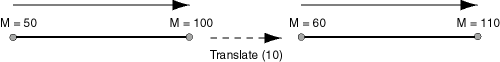
An exception is raised if geom_segment has an invalid geometry type or dimensionality.
The _3D format of this function (SDO_LRS.TRANSLATE_MEASURE_3D) is available. For information about _3D formats of LRS functions, see Section 6.4.
Examples
The following example translates (shifts) by 10 the geometric segment representing Route 1. (This example uses the definitions from the example in Section 6.6.)
SELECT SDO_LRS.TRANSLATE_MEASURE(a.route_geometry, m.diminfo, 10)
  FROM lrs_routes a, user_sdo_geom_metadata m
  WHERE m.table_name = 'LRS_ROUTES' AND m.column_name = 'ROUTE_GEOMETRY'
    AND a.route_id = 1;

SDO_LRS.TRANSLATE_MEASURE(A.ROUTE_GEOMETRY,M.DIMINFO,10)(SDO_GTYPE, SDO_SRID, SD
--------------------------------------------------------------------------------
SDO_GEOMETRY(3002, NULL, NULL, SDO_ELEM_INFO_ARRAY(1, 2, 1), SDO_ORDINATE_ARRAY(
2, 2, 10, 2, 4, 12, 8, 4, 18, 12, 4, 22, 12, 10, 28, 8, 10, 32, 5, 14, 37))
Format
SDO_LRS.VALID_GEOM_SEGMENT(
geom_segment IN MDSYS.SDO_GEOMETRY
[, dim_array IN MDSYS.SDO_DIM_ARRAY]
) RETURN VARCHAR2;
Description
Checks if a geometry object is a valid geometric segment.
Parameters
Geometric segment to be checked for validity.
Dimensional information array corresponding to geom_segment, usually selected from one of the xxx_SDO_GEOM_METADATA views.
Usage Notes
This function returns TRUE if geom_segment is valid and FALSE if geom_segment is not valid.
Measure information is assumed to be stored in the last element of the SDO_DIM_ARRAY in the Oracle Spatial metadata.
This function only checks for geometry type and number of dimensions of the geometric segment. To further validate measure information, use the IS_GEOM_SEGMENT_DEFINED function.
The _3D format of this function (SDO_LRS.VALID_GEOM_SEGMENT_3D) is available. For information about _3D formats of LRS functions, see Section 6.4.
Examples
The following example checks if the geometric segment representing Route 1 is valid. (This example uses the definitions from the example in Section 6.6.)
SELECT  SDO_LRS.VALID_GEOM_SEGMENT(route_geometry)
  FROM lrs_routes WHERE route_id = 1;

SDO_LRS.VALID_GEOM_SEGMENT(ROUTE_GEOMETRY)
--------------------------------------------------------------------------------
TRUE
Format
SDO_LRS.VALID_LRS_PT(
point IN MDSYS.SDO_GEOMETRY
[, dim_array IN MDSYS.SDO_DIM_ARRAY]
) RETURN VARCHAR2;
Description
Checks if an LRS point is valid.
Parameters
Point to be checked for validity.
Dimensional information array corresponding to point, usually selected from one of the xxx_SDO_GEOM_METADATA views.
Usage Notes
This function returns TRUE if point is valid and FALSE if point is not valid.
This function checks if point is a point with measure information, and it checks for the geometry type and number of dimensions for the point geometry.
All LRS point data must be stored in the SDO_ELEM_INFO_ARRAY and SDO_ORDINATE_ARRAY, and cannot be stored in the SDO_POINT field in the SDO_GEOMETRY definition of the point.
The _3D format of this function (SDO_LRS.VALID_LRS_PT_3D) is available. For information about _3D formats of LRS functions, see Section 6.4.
Examples
The following example checks if point (9,3,NULL) is a valid LRS point. (This example uses the definitions from the example in Section 6.6.)
SELECT  SDO_LRS.VALID_LRS_PT(
    MDSYS.SDO_GEOMETRY(3001, NULL, NULL,
       MDSYS.SDO_ELEM_INFO_ARRAY(1, 1, 1),
       MDSYS.SDO_ORDINATE_ARRAY(9, 3, NULL)),
    m.diminfo)
    FROM lrs_routes a, user_sdo_geom_metadata m
    WHERE m.table_name = 'LRS_ROUTES' AND m.column_name = 'ROUTE_GEOMETRY'
      AND a.route_id = 1;

SDO_LRS.VALID_LRS_PT(MDSYS.SDO_GEOMETRY(3001,NULL,NULL,MDSYS.SDO_ELEM_INFO_ARRAY
--------------------------------------------------------------------------------
TRUE
Format
SDO_LRS.VALID_MEASURE(
geom_segment IN MDSYS.SDO_GEOMETRY,
measure IN NUMBER
) RETURN VARCHAR2;
or
SDO_LRS.VALID_MEASURE(
geom_segment IN MDSYS.SDO_GEOMETRY,
dim_array IN MDSYS.SDO_DIM_ARRAY,
measure IN NUMBER
) RETURN VARCHAR2;
Description
Checks if a measure falls within the measure range of a geometric segment.
Parameters
Geometric segment to be checked to see if it falls within the measure range of measure.
Dimensional information array corresponding to geom_segment, usually selected from one of the xxx_SDO_GEOM_METADATA views.
Geometric segment to be checked to see if geom_segment falls within its measure range.
Usage Notes
This function returns TRUE if measure falls within the measure range of geom_segment and FALSE if measure does not fall within the measure range of geom_segment.
An exception is raised if geom_segment has an invalid geometry type or dimensionality.
The _3D format of this function (SDO_LRS.VALID_MEASURE_3D) is available. For information about _3D formats of LRS functions, see Section 6.4.
Examples
The following example checks if 50 is a valid measure on the Route 1 segment. The function returns FALSE because the measure range for that segment is 0 to 27. For example, if the route is 27 miles long and there is a mile marker at one-mile intervals, there is no 50-mile marker because the last marker is the 27-mile marker. (This example uses the definitions from the example in Section 6.6.)
SELECT  SDO_LRS.VALID_MEASURE(route_geometry, 50)
  FROM lrs_routes WHERE route_id = 1;

SDO_LRS.VALID_MEASURE(ROUTE_GEOMETRY,50)
--------------------------------------------------------------------------------
FALSE
Format
SDO_LRS.VALIDATE_LRS_GEOMETRY(
geom_segment IN MDSYS.SDO_GEOMETRY
[, dim_array IN MDSYS.SDO_DIM_ARRAY]
) RETURN VARCHAR2;
Description
Checks if an LRS geometry is valid.
Parameters
Geometric segment to be checked.
Dimensional information array corresponding to geom_segment, usually selected from one of the xxx_SDO_GEOM_METADATA views.
Usage Notes
This function returns TRUE if geom_segment is valid and one of the following error codes if geom_segment is not valid:
13331 (invalid LRS geometry type)
13335 (measure information not defined)
The _3D format of this function (SDO_LRS.VALIDATE_LRS_GEOMETRY_3D) is available. For information about _3D formats of LRS functions, see Section 6.4.
Examples
The following example checks if the Route 1 segment is a valid LRS geometry. (This example uses the definitions from the example in Section 6.6.)
SELECT SDO_LRS.VALIDATE_LRS_GEOMETRY(a.route_geometry, m.diminfo)
   FROM lrs_routes a, user_sdo_geom_metadata m
   WHERE m.table_name = 'LRS_ROUTES' AND m.column_name = 'ROUTE_GEOMETRY'
   AND a.route_id = 1;

SDO_LRS.VALIDATE_LRS_GEOMETRY(A.ROUTE_GEOMETRY,M.DIMINFO)
--------------------------------------------------------------------------------
TRUE
|
 Copyright © 1999, 2002 Oracle Corporation All rights reserved |
|